
Waterproof Chart Cape Coral Canals Large Print 7E
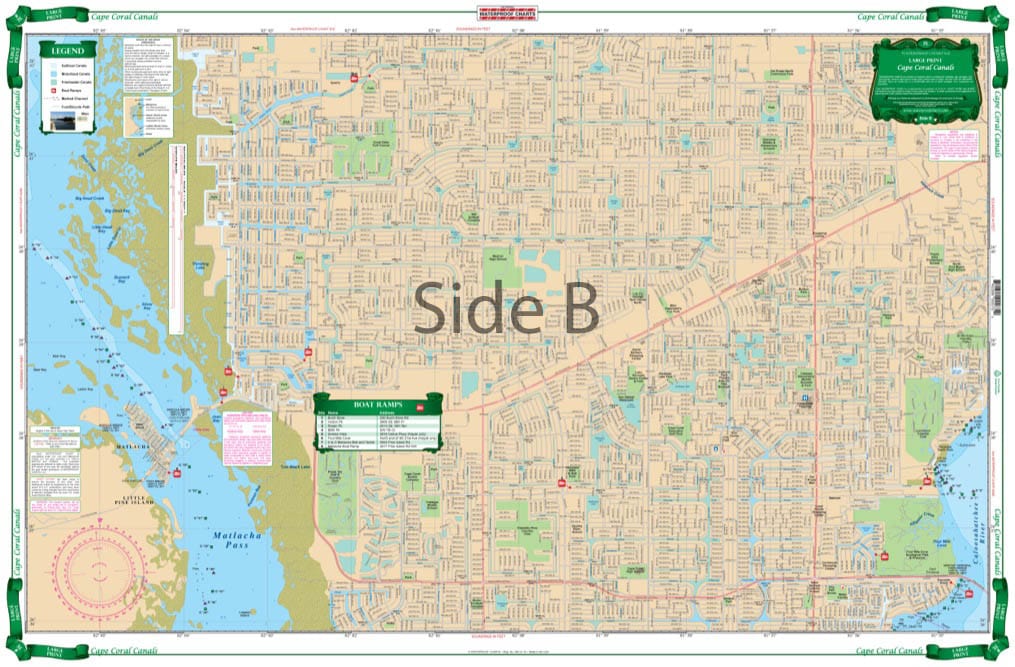
Explore the intricate waterways of Cape Coral with our high-quality Waterproof Chart. This chart provides extensive coverage of the Cape Coral Canals, making it an essential tool for boaters, anglers, and outdoor enthusiasts alike. Experience detailed navigation while ensuring your adventure remains uninterrupted by inclement weather.
The Waterproof Chart features a large print design, ensuring readability and ease of use for all outdoor activities. Ideal for both novices and seasoned navigators, this chart clearly outlines the Caloosahatchee River and its surrounding canals, ensuring you can navigate with confidence.
- Comprehensive Coverage: The south side includes detailed markings from Shell Point to the Midpoint Bridge. Additionally, the reverse side highlights all canals from Veterans Parkway to Kismet Parkway, making every fishing spot and recreational area easily accessible.
- Color-Coded Navigation: Each canal is color-coded to indicate its suitability for travel; whether you're using a sailboat, a powerboat, or navigating through fresh water canals, our chart provides essential information for safe passage.
Furthermore, the Waterproof Chart displays all bridge heights, allowing you to plan your route around clearance requirements seamlessly. Whether you are fishing, tubing, or simply enjoying a day out on the water, this chart guarantees that you can make the most of your time on the beautiful Cape Coral waterways.
Invest in your boating experience with this indispensable Waterproof Chart. Its durability and clarity will keep you informed and safe as you explore the fantastic aquatic landscapes of Cape Coral.
Informations sur le produit
Informations sur le produit
Livraison et retours
Livraison et retours

Waterproof Chart Cape Coral Canals Large Print 7E
Waterproof Chart Cape Coral Canals Large Print 7E
Explore the intricate waterways of Cape Coral with our high-quality Waterproof Chart. This chart provides extensive coverage of the Cape Coral Canals, making it an essential tool for boaters, anglers, and outdoor enthusiasts alike. Experience detailed navigation while ensuring your adventure remains uninterrupted by inclement weather.
The Waterproof Chart features a large print design, ensuring readability and ease of use for all outdoor activities. Ideal for both novices and seasoned navigators, this chart clearly outlines the Caloosahatchee River and its surrounding canals, ensuring you can navigate with confidence.
- Comprehensive Coverage: The south side includes detailed markings from Shell Point to the Midpoint Bridge. Additionally, the reverse side highlights all canals from Veterans Parkway to Kismet Parkway, making every fishing spot and recreational area easily accessible.
- Color-Coded Navigation: Each canal is color-coded to indicate its suitability for travel; whether you're using a sailboat, a powerboat, or navigating through fresh water canals, our chart provides essential information for safe passage.
Furthermore, the Waterproof Chart displays all bridge heights, allowing you to plan your route around clearance requirements seamlessly. Whether you are fishing, tubing, or simply enjoying a day out on the water, this chart guarantees that you can make the most of your time on the beautiful Cape Coral waterways.
Invest in your boating experience with this indispensable Waterproof Chart. Its durability and clarity will keep you informed and safe as you explore the fantastic aquatic landscapes of Cape Coral.
Original : $27.95
-70%$27.95
$8.38Informations sur le produit
Informations sur le produit
Livraison et retours
Livraison et retours
Description
Explore the intricate waterways of Cape Coral with our high-quality Waterproof Chart. This chart provides extensive coverage of the Cape Coral Canals, making it an essential tool for boaters, anglers, and outdoor enthusiasts alike. Experience detailed navigation while ensuring your adventure remains uninterrupted by inclement weather.
The Waterproof Chart features a large print design, ensuring readability and ease of use for all outdoor activities. Ideal for both novices and seasoned navigators, this chart clearly outlines the Caloosahatchee River and its surrounding canals, ensuring you can navigate with confidence.
- Comprehensive Coverage: The south side includes detailed markings from Shell Point to the Midpoint Bridge. Additionally, the reverse side highlights all canals from Veterans Parkway to Kismet Parkway, making every fishing spot and recreational area easily accessible.
- Color-Coded Navigation: Each canal is color-coded to indicate its suitability for travel; whether you're using a sailboat, a powerboat, or navigating through fresh water canals, our chart provides essential information for safe passage.
Furthermore, the Waterproof Chart displays all bridge heights, allowing you to plan your route around clearance requirements seamlessly. Whether you are fishing, tubing, or simply enjoying a day out on the water, this chart guarantees that you can make the most of your time on the beautiful Cape Coral waterways.
Invest in your boating experience with this indispensable Waterproof Chart. Its durability and clarity will keep you informed and safe as you explore the fantastic aquatic landscapes of Cape Coral.


